
Polar Vortex Collapse Weather Forecast – What Sudden Stratospheric Warming Signals?
![]() • January 31, 2026
• January 31, 2026
❄️ WEATHER ALERT UPDATE
February 2026 Polar Vortex Collapse Forecast:
Long-range meteorological models are pointing toward a major polar vortex collapse in February 2026, following a confirmed sudden stratospheric warming (SSW) event. Based on years of closely tracking global weather patterns, this winter is shaping up to be anything but typical.
Key Facts:
- Event: Sudden Stratospheric Warming (SSW)
• Expected Impact Window: February–March 2026
• Primary Risk: Polar vortex split and sustained cold pattern
• Affected Regions: UK, Europe, North America
• Confidence Level: Increasing, based on multi-model agreement
Residents, forecasters, and policymakers will be watching closely in the coming weeks as atmospheric signals become clearer, with preparations potentially needed for a prolonged and disruptive late-winter period.
Let’s break down what’s unfolding in the atmosphere above us, and what it means for the ground beneath our feet.
What Is the Polar Vortex and Why Does It Matter in Winter?
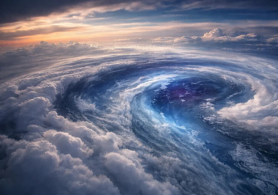
The polar vortex is a large area of low pressure and cold air surrounding the Earth’s poles. Think of it as a spinning dome of freezing air that hovers high in the atmosphere. During winter, this vortex strengthens and descends, influencing weather across the Northern Hemisphere.
Structure and Function
The polar vortex exists in two main layers:
- Stratospheric Polar Vortex (SPV): Found between 10–50 km above the Earth, this is the key player in long-term cold weather patterns.
- Tropospheric Polar Vortex: Closer to the surface and more directly responsible for short-term cold snaps.
When the SPV is strong, it traps Arctic air over the pole. When it weakens or splits, that cold air escapes into lower latitudes, like the UK.
“The polar vortex is like a lid keeping the freezer shut. When it cracks open, the cold spills out,” explains Dr. Marina Petrov, atmospheric scientist at the University of Reading.
What Is Sudden Stratospheric Warming (SSW)?
SSW is a rare atmospheric event where temperatures in the stratosphere rise dramatically, by as much as 50°C in a matter of days. Despite the term “warming,” the downstream effect usually results in colder surface weather.
What Triggers an SSW?
- Large-scale Rossby waves in the troposphere move upward
- These waves break and deposit energy in the stratosphere
- The polar vortex slows, reverses winds, and may split into two smaller vortices
This sudden disorganisation of the polar vortex changes jet stream paths, allowing frigid Arctic air to plunge southward.
Notable Past SSW Events
- 2010: Substantial snowfall and cold across much of Europe
- 2013: UK experienced late-season cold and significant frost damage
- 2018: “Beast from the East” paralysed parts of the UK with snow and sub-zero temperatures
The current setup for February 2026 is eerily similar, perhaps even more pronounced.
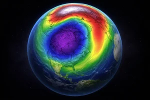
What Does the February 2026 Polar Vortex Forecast Show?
As mid-February approaches, ensemble data from major forecast models is signalling a significant shift in upper atmospheric behaviour. The stratospheric polar vortex, which normally helps stabilise winter conditions across the Northern Hemisphere, is forecast to undergo severe weakening and structural disruption.
At the 10mb level, wind speeds are projected to approach reversal,one of the clearest indicators of a major Sudden Stratospheric Warming event. Forecast temperature anomalies of 45–50°C above average suggest one of the most intense stratospheric disturbances seen in decades.
Forecast Indicators (Stratosphere – February 2026)
| Metric | Value | Implication |
|---|---|---|
| 10mb Wind Speed | Near 0 m/s or reversed | Strong vortex disruption |
| Temperature Anomaly (10mb) | +45 to +50°C above norm | Rapid stratospheric warming |
| Pressure Anomaly (50mb) | Rising over the Pole | High-latitude blocking forming |
| Vortex Structure (3D Model) | Splitting into two lobes | Arctic air displacement likely |
What this tells us is that the polar vortex is no longer behaving as a cohesive circulation system. Instead, it’s splitting into multiple lobes, each of which could act as a gateway for cold Arctic air to spill southward, well into the mid-latitudes.
“We’re not just seeing one signal, we’re seeing a full atmospheric alignment that strongly favours a classic cold wave setup,”
– Simon Warburton, Meteorologist, Severe-Weather.eu
The forecast evolution over the next 10–14 days is critical. If current trends hold, downstream surface effects will be pronounced, particularly for Europe and North America, with the UK firmly within the likely impact zone.
How Does a Collapsed Polar Vortex Affect UK Weather?
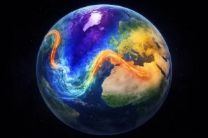
When the stratospheric polar vortex collapses, the disruption filters down into the lower atmosphere, significantly altering the jet stream that typically governs UK weather.
Instead of a strong west-to-east flow that brings mild Atlantic air, the jet stream can weaken, bend, and slow, creating opportunities for cold Arctic or continental air to reach Britain.
For much of the UK, including London and the South East, this pattern increases the likelihood of prolonged cold spells, particularly when high-pressure blocking systems set in. These blocks prevent milder Atlantic air from returning and instead draw in cold, dry air from eastern Europe and Scandinavia.
Key Impacts Expected Across the UK and London:
- Sharply colder nights, including in urban areas like London, where minimum temperatures could dip below freezing despite the heat island effect
- Easterly or northeasterly winds import dry, cold air, raising the chance of icy mornings and frost in and around the capital
- Higher snowfall risk in eastern and elevated areas, with light snow flurries or sleet possible even in low-lying areas such as London suburbs
- Widespread frost, affecting roads, public transport, and daily commuting
- Increased pressure on the city’s transport network, energy demand, and vulnerable populations
Expected Pressure Systems
| Region | Pressure Trend | Resulting Flow |
|---|---|---|
| Greenland | Strong high pressure | Northerly to easterly winds |
| Scandinavia | Persistent high ridges | Blocking milder Atlantic air |
| Central Europe | Developing cold troughs | Frost and snow potential |
In densely populated areas like London, even minor snow or ice events can have outsized impacts on infrastructure, transport, and emergency services.
If this pattern locks in, the capital could face several consecutive days of freezing temperatures, slippery conditions, and heightened pressure on local councils and services.
Could This Cold Spell Linger Into Early Spring?

Forecast trends suggest the cold spell tied to the polar vortex collapse may extend well beyond February. One of the key concerns with sudden stratospheric warming (SSW) events is their delayed but persistent surface impact. Once cold air becomes entrenched due to blocking high-pressure systems, it can prove difficult to dislodge.
For London, this could mean a longer-than-usual cold phase, with daytime temperatures struggling to rise above single digits and overnight lows frequently dipping below freezing, particularly in suburban and rural edges of Greater London.
Timeline of Surface Weather Effects from SSW
| Time After SSW | Typical Surface Effect |
|---|---|
| 0–7 Days | Minimal surface change |
| 8–14 Days | Jet stream reconfiguration |
| 15–30 Days | Cold air intrusions across UK and Europe |
| 31–45 Days | Potential continued blocking, delayed spring |
If the current forecasts materialise, London may not escape the wider pattern, despite its normally temperate climate. With March now looking increasingly unsettled, early spring warmth could be delayed, making this one of the longest-lasting winter impacts in recent memory.
How Is the Transition From La Niña to El Niño Shaping Weather Patterns?
The shift from La Niña conditions to a developing El Niño has added another variable to this complex winter. Oceanic conditions in the tropical Pacific influence global atmospheric circulation, including the strength and position of the jet stream.
ENSO’s Role in This Event
- La Niña, now weakened, had supported a stronger polar vortex
- With its departure, vortex stability has collapsed, allowing for sudden stratospheric warming
- El Niño onset is causing the subtropical jet stream to gain dominance, altering upper-level patterns
ENSO’s Relevance to the UK
- As the jet stream shifts, Europe becomes increasingly vulnerable to cold intrusions from the north and east
- This transition phase between ENSO patterns tends to produce volatile and erratic weather, particularly during late winter into early spring
Overall, the interplay between stratospheric and oceanic signals is driving the current extreme potential. While ENSO isn’t directly causing the vortex collapse, it is certainly helping to shape the consequences.
Is This a Typical Weather Pattern or a Sign of Climate Anomalies?
Polar vortex collapses are not new, but meteorologists have noted changes in how often and how intensely they occur in recent decades. Ongoing Arctic warming may be subtly altering atmospheric behaviour, particularly by reducing the temperature contrast between the pole and mid-latitudes. This can weaken the jet stream, making it more prone to large meanders that allow cold air to spill southwards.
The loss of Arctic sea ice may also be playing a role by disrupting established circulation patterns. While an increase in sudden stratospheric warming events since the early 2000s has been observed, scientists stress that more long-term data is needed to confirm a clear trend.
For now, these events are considered natural variability, but climate shifts may be amplifying their impacts. This highlights how closely connected global weather systems truly are.
Weather Model Snapshot: Key Forecast Indicators Explained
Forecast models are a cornerstone of modern meteorology. With multiple models currently signalling a significant polar disruption, confidence in this forecast is unusually high.
GFS Model (Global Forecast System)
- Shows wind reversal at 10mb stratospheric level
- Projects cold anomalies centred over the UK, Scandinavia, and central Europe
- Suggests the vortex split will be fully realised by mid-February
ECMWF Ensemble
- Reflects strong stratospheric warming and reduced polar vortex intensity
- Predicts blocking patterns extending into early March
- Indicates potential for multiple cold surges rather than just one-off event
Model agreement doesn’t guarantee certainty, but the current synchronisation across systems is rare. This alignment strengthens the case for a meaningful cold outbreak in the UK.
Final Thoughts
As I assess the growing consistency across forecast models and historical patterns, it’s clear this event is more than short-term noise. The signals emerging from sudden stratospheric warming, aligned with broader atmospheric shifts, suggest a period of notable weather disruption that deserves close attention rather than dismissal.
In practical terms, staying informed will be key. Monitoring Met Office updates and reliable local forecasts can help households and businesses respond quickly. It’s also sensible to prepare for possible transport delays, supply chain disruption, and short-notice infrastructure impacts.
While the precise severity remains uncertain, the convergence of indicators suggests the UK winter could remain unsettled well into early March.
FAQs – Understanding Polar Vortex Collapse and SSW Events
What exactly is a sudden stratospheric warming event?
It’s a rapid temperature rise in the stratosphere that weakens the polar vortex and often leads to cold spells in the UK.
How does the polar vortex impact UK winter weather?
When strong, it keeps Arctic air locked up. When weak or split, it allows cold air to reach the UK and Europe.
Is this weather event connected to climate change?
While not directly caused by climate change, shifting polar conditions may increase the frequency of such disruptions.
How long do polar vortex disruptions typically last?
Surface impacts often begin 10–14 days after an SSW and can persist for up to 40 days.
Could we see more snowfall in the UK this February?
Yes. With easterly winds and blocking patterns, snow risk increases, especially in eastern and northern parts.
What’s the difference between stratospheric and tropospheric effects?
Stratospheric changes happen high above, while tropospheric impacts are felt directly in surface weather.
How accurate are long-range forecasts for events like this?
While not perfect, today’s models offer strong early warning when multiple signals (like now) align.