
Halifax Road Closures 2026: Which Town Centre Roads Are Closed and For How Long?
![]() • February 27, 2026
• February 27, 2026
🚧 HALIFAX ROAD CLOSURES 2026 – TOWN CENTRE UPDATE & A629 WORKS
Current Situation: Multiple road closures remain in place across Halifax town centre due to the ongoing A629 Phase 2 Eastern Corridor works, alongside temporary disruption affecting North Bridge.
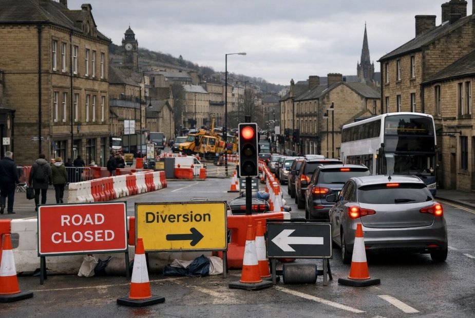
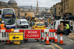
Long-Term Restrictions: Key northbound closures on Charles Street, Square Road, Church Street and South Parade are expected to continue until 2 June 2027. Bank Bottom remains closed eastbound until June 2027, with Blackedge operating one-way until October 2027.
📍 Most Affected Areas: Rail Station gateway, Square Chapel approach, Bank Bottom, Lower Kirkgate, Market Street and North Bridge.
🚌 Public Transport & Access: Bus routes and taxi ranks have been adjusted. Woolshops Car Park remains accessible, though exit restrictions apply. Diversions are signposted but congestion is expected during peak hours.
⚠️ Travel Advice: Drivers are strongly advised to allow extra journey time and follow official diversion routes via Skircoat Road, Bull Green and Broad Street when travelling northbound through Halifax.
- Main Project: A629 Phase 2 Halifax Town Centre (Eastern Corridor)
- Major Closures: Charles Street, Square Road, Church Street, South Parade (northbound)
- Bank Bottom: Closed eastbound (Cripplegate to Southowram Bank)
- Blackedge: Temporary one-way restriction
- North Bridge: Subject to incident-related disruption
- Estimated Completion: Phased works continuing into mid/late 2027
What Are the Main Halifax Road Closures in 2026 Right Now?
As of 26 February 2026, Halifax road closures fall into two categories: long-term planned works linked to the A629 Phase 2 Halifax town centre scheme, and shorter-term disruption caused by incidents.
The most significant planned closures relate to the Eastern Corridor section of the project. These restrictions affect Charles Street, Square Road, Church Street, South Parade, Bank Bottom and sections of Lower Kirkgate and Cripplegate.
Some of these closures are expected to remain in place until June 2027, with others extending to October 2027.
In addition, North Bridge has experienced major disruption due to an ongoing police incident, leading to heavy congestion and temporary access issues across surrounding routes.
A Calderdale Council spokesperson recently explained:
“The works currently underway form part of our wider transformation of Halifax town centre. While we recognise the inconvenience, these changes are designed to improve safety, accessibility and the overall experience for residents and visitors.”
The combination of regeneration and reactive disruption means drivers should check routes carefully before travelling into the town centre.
Which Halifax Town Centre Roads Are Closed – and What Are the End Dates?
The following table summarises the key Halifax road closures in 2026, including direction of travel, location details and expected duration.
Key Halifax Road Closures (as of February 2026)
| Road | Restriction | Location (Junction to Junction) | Expected End Date | Reason |
|---|---|---|---|---|
| Charles Street | Closed northbound | Hunger Hill to King Street | 2 June 2027 | A629 Phase 2 Eastern Corridor |
| Square Road | Closed northbound | Hunger Hill to King Street | 2 June 2027 | Eastern Corridor works |
| Church Street | Closed northbound | Hunger Hill to King Street | 2 June 2027 | Eastern Corridor works |
| South Parade | Closed northbound | Hunger Hill to King Street | 2 June 2027 | Eastern Corridor works |
| Cripplegate / Lower Kirkgate | Closed northbound | Berry Lane to King Street | June 2027 | Realignment works |
| Bank Bottom | Closed eastbound | Cripplegate to Southowram Bank | June 2027 | Eastern Corridor realignment |
| Blackedge | One-way restriction | Square Road to Thomas Street (no westbound travel) | October 2027 | Traffic management phase |
Although northbound traffic is restricted on several routes, southbound movement is often still permitted. Drivers should carefully review signage on approach.
Is North Bridge in Halifax Closed Because of an Incident?

As of 26 February 2026, North Bridge has experienced major disruption linked to a police incident. Emergency services presence led to traffic restrictions and congestion in surrounding streets, particularly affecting routes feeding into Halifax town centre from the north.
While such closures are typically temporary, they can cause significant knock-on delays. Surrounding areas such as Broad Street, Northgate and Cross Hills have seen heavier traffic flows during peak times.
Drivers are advised to:
- Check live updates from Calderdale Council and local traffic services
- Allow additional journey time during morning and evening peaks
- Consider alternative approaches via Skircoat Road or Bull Green
Unlike planned Halifax road closures associated with A629 works, incident-based restrictions may change rapidly throughout the day.
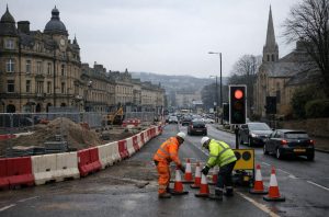
How Long Will A629 Phase 2 Works Disrupt Halifax Town Centre?
The A629 Phase 2 Halifax town centre project is one of the largest transport and regeneration schemes undertaken in the area. Construction began in phases, with western corridor works nearing completion by late 2025, while eastern corridor works continue through 2026 and into 2027.
The Eastern Gateway section, connecting Halifax Rail Station to the town centre, is a core focus. The scheme includes:
- A new traffic alignment east of the former Hughes Corporation building
- Rising bollards to create pedestrian-priority zones
- Public realm improvements near Square Chapel and the Piece Hall
- Realignment of Lower Kirkgate and Bank Bottom
According to project officials:
“We’re creating an open and welcoming public space on the approach to the Piece Hall, alongside safer walking and cycling routes into the town centre.”
Some long-term traffic restrictions are therefore expected to remain until mid to late 2027, particularly where structural realignments are required.
Which Parts of Halifax Town Centre Are Most Affected by the Closures?
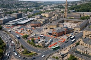
Several key areas within Halifax town centre are experiencing the greatest impact from the current road closures, particularly where long-term A629 Phase 2 works overlap with high-traffic routes and major landmarks.
Rail Station, Square Chapel and Eastern Gateway
The area connecting Halifax Rail Station to Square Chapel and the Piece Hall is undergoing substantial redesign. Charles Street and Square Road are central to this transformation, with bus gates introduced to prioritise buses, taxis, cycles and motorcycles in certain sections.
Woolshops Car Park remains accessible, though the Hatters Fold exit is restricted to right-turn-only onto Square Road.
Bottom of Town: Bank Bottom and Lower Kirkgate
The bottom-of-town area has seen some of the most significant traffic adjustments due to road realignment and long-term closures.
Key impacts include:
- Eastbound closure of Bank Bottom between Cripplegate and Southowram Bank
- Northbound restrictions on Lower Kirkgate
- Adjusted junction layouts to simplify vehicle movements
- Reduced right-turn conflicts to improve safety
- Increased reliance on perimeter diversion routes
These changes are designed to improve overall journey flow around the town rather than through the most congested central sections.
Market Street and Central Halifax
In the heart of Halifax, Market Street is being pedestrianised to create a more people-focused environment and strengthen the retail core. Vehicle access is now limited, with bollards regulating permitted entry and preventing general through-traffic.
Taxi provision has been relocated further south to support the expanded pedestrian zone, and bus stops have been repositioned to improve connectivity between public transport hubs.
While these changes require short-term adjustment, they are intended to enhance accessibility, safety and the overall town centre experience in the long term.
What Diversions Are in Place for Drivers Heading Northbound Through Halifax?
For northbound traffic affected by closures on Charles Street, Square Road, Church Street and South Parade, the commonly advised alternative route is via:
- Skircoat Road
- Portland Place
- Commercial Street
- Fountain Street
- Barum Top
- Bull Green
- Cow Green
- Broad Street
- Northgate
- Winding Road
While this route maintains through access, drivers should expect congestion at peak times, particularly where signal upgrades are ongoing.
What’s the Best Diversion if Bank Bottom Is Closed Eastbound?
With Bank Bottom closed eastbound from Cripplegate to Southowram Bank, drivers heading towards Charlestown Road, New Bank or connections to the A58 may be redirected through:
- Skircoat Road
- Portland Place
- Commercial Street
- Fountain Street
- Bull Green
- Broad Street
- Orange Street
- Burdock Way
- New Bank
This route shifts traffic away from the bottom-of-town bottleneck and distributes vehicles through upgraded junctions designed to handle higher capacity.
Eastbound Diversion Overview:
| Origin | Closed Section | Recommended Diversion | Notes |
|---|---|---|---|
| Cripplegate | Bank Bottom (eastbound) | Via Skircoat Road & Bull Green | Expect signal delays |
| Lower Kirkgate | Northbound restriction | Use Commercial Street loop | Peak congestion likely |
| Square Road (westbound) | Blackedge restriction | Horton Street | Eastbound maintained |
Planning journeys outside peak commuting hours may significantly reduce delay, particularly where signal upgrades and phased construction continue to affect junction efficiency.
Can Drivers Still Access Woolshops Car Park and Key Town Centre Parking?
Despite ongoing Halifax road closures, drivers can still access Woolshops Car Park, although routes may differ from usual travel patterns. Temporary traffic management and diversion signage are in place, so motorists should allow extra time and follow updated directions when entering or leaving the town centre.
Drivers should note that exiting via Hatters Fold is restricted to a right turn onto Square Road, which may affect onward journeys.
Some nearby streets also operate bus gates, limiting access for general vehicles at certain times. Construction phases may lead to further short-term changes, with signage guiding traffic accordingly.
To support accessibility, Blue Badge parking spaces have been introduced on Princess Street, while taxi ranks have been relocated to improve pedestrian safety and traffic flow.
What Changes Are Being Made to Roads, Crossings and Walking Routes?
The A629 Phase 2 scheme goes beyond road closures. It introduces a redesigned travel framework focused on safety, sustainability and long-term growth.
Key improvements include:
- Removal of the Bull Green roundabout and installation of signal-controlled junctions
- Subway infill at Cow Green, replaced with pedestrian crossings
- New cycle lanes at major junctions
- Upgraded signal coordination to improve traffic flow
- Landscaping and tree planting at gateways
A project official noted:
“These improvements are about reducing traffic dominance in the heart of Halifax while maintaining efficient circulation around the perimeter.”
Major Infrastructure Enhancements:
| Area | Upgrade | Benefit |
|---|---|---|
| Bull Green | Roundabout removal | Smoother vehicle flow |
| Cow Green | Subway infill | Improved pedestrian safety |
| Market Street | Pedestrianisation | Enhanced public realm |
| Charles Street | Bus gate & cycle lanes | Public transport priority |
| Lower Kirkgate | Road realignment | Reduced turning conflicts |
How Will Halifax Road Closures Affect Buses, Taxis, Deliveries and Businesses?
Bus routes have been adjusted in phases to align with construction. Services previously diverted during Bull Green works are gradually returning, though additional stop changes may occur as Eastern Corridor works continue.
Taxi provision has shifted away from Market Street to create pedestrian space. Businesses near pedestrianised areas may need to coordinate deliveries around permitted loading windows and temporary Traffic Regulation Orders (TROs).
A council representative summarised the approach:
“We are committed to maintaining business continuity throughout the project, with phased traffic management and clear communication.”
Where Can People Check Official Halifax Roadworks Updates and TRO Notices?
To stay informed about Halifax road closures and diversion changes, residents and visitors should rely on official and verified sources.
- Monitor Calderdale Council’s A629 Phase 2 updates
- Review current Traffic Regulation Orders (TROs) on the council’s highways page
- Follow verified local news sources for incident-based disruption
- Check WY Metro for bus service updates
Because incident-related closures can change quickly, combining official council updates with live traffic tools provides the most reliable picture.
Conclusion
Halifax road closures in 2026 represent a significant transitional period for the town. While drivers and businesses face ongoing disruption, the A629 Phase 2 project aims to deliver safer roads, improved air quality, better public spaces and enhanced connectivity between the rail station, bus station and retail core.
Understanding which roads are closed, how long restrictions will remain in place, and where diversion routes operate allows residents and visitors to navigate Halifax town centre more effectively.
As regeneration progresses, Halifax is steadily reshaping its transport network for the long term, even if the short-term journey requires a little more planning.
Frequently Asked Questions
How can drivers find out if a Halifax road closure is still in place today?
Drivers should check Calderdale Council’s official website and current TRO listings. Live traffic apps and local news platforms can provide real-time updates on incident-based disruption.
Do northbound closures mean the road is open southbound?
In many cases, yes. Several Halifax road closures apply only to northbound traffic. However, drivers must follow posted signage, as restrictions can change during different construction phases.
Are diversions in Halifax clearly signed?
Yes. Temporary signage is installed around affected junctions. Nonetheless, congestion can build quickly, particularly during commuting hours.
Will Halifax town centre works affect access to the railway station?
Access remains possible, though routes may differ from previous layouts. Eastern Gateway works are specifically designed to improve connectivity between the station and town centre once completed.
What is a Traffic Regulation Order (TRO)?
A TRO is a legal mechanism that allows councils to restrict or alter traffic movement. Temporary TROs are often used during construction phases.
Are bus gates enforced in Halifax?
Yes. Bus gates restrict access to authorised vehicles. Drivers entering restricted sections may face penalties.
When are Halifax road closures expected to end?
Some closures, particularly in the Eastern Corridor, are scheduled to continue until June 2027, with certain one-way restrictions lasting until October 2027.